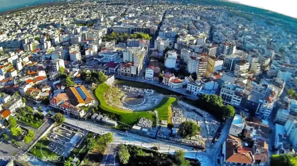
Larissa - Thessaly (Greece)
The prefecture of Larissa is one of the four prefectures of the geographical part of Thessaly. It borders to the north with the prefectures of Pieria and Kozani, to the west with the prefecture of Grevena, Trikala and Karditsa, to the south with the prefecture of Fthiotida and Magnesia, to the east the Aegean Sea.
One of the characteristics of this area are the big plains, which are surrounded by high mountains. In the north part is situated Olympus, the highest mountain of Greece. In the eastern part of the prefecture the mountain Ossa (Kissavos) is located. Between Olympus and Kissavos lies the Valley of Tempi. In the central part of the prefecture of Larissa lies the plain of Larissa which is one of the biggest and most fertile plains of Greece. In the north of the plain of Larissa lies the plain of Tyrnavos and the valleys or plains of Titarisio, Elassona and Farsala.
The largest river of the prefecture of Larissa and of all of Thessaly is Pinios (Penaeus). The river enters the territory of the prefecture of Larissa among the hills of Zarko and Titanio, streams through the plains of Larissa and Tyrnavos, and flows into the Aegean Sea. The prefecture of Larissa is one of the best economically developed regions in Greece due to the large cultivated agricultural areas and the development of industry. Agriculture is an important sector for the economy of the county. Among the crops raised here are cereals, legumes, beets, cotton, watermelons and melons. Livestock farming consists mainly of sheep and goats, and the production of livestock products such as meat, cheese, butter. There are also large factories which produce sugar, flour and other staples.
Mount Olympus
Olympus is the highest mountain in Greece and much of this is located in the district of Larissa. From Elassona, you'll not have to go much further to reach the top. On this route we will see great mountain villages, each with its own style and unique cuisine, sample the local specialties and also make a visit to the lake of Kefalovriso at 1160 meters (3,805 feet) altitude to eat trout.
However, the most beautiful and highly recommended region of Larissa is "the Tempi." In this area there are also nice traditional villages such Ampelakia and Rapsani where the architecture is striking. Visit the anthropological museum in Ampelakia that is housed in the 3-story traditional house of Schwartz. Those who love the sea must stop in Stomio, Karitsa, Kokkino Nero and Agiokampos. Agiokampos is particularly popular among young people.
Η Περιφερειακή Ενότητα (Π.Ε.) Λάρισας είναι μια από τις 74 Περιφερειακές Ενότητες της Ελλάδας που συστάθηκαν με την εφαρμογή του Προγράμματος Καλλικράτης. Η Π.Ε. Λάρισας ανήκει γεωγραφικά και διοικητικά στην Περιφέρεια Θεσσαλίας.
Συγκεκριμένα είναι μία από τις πέντε Περιφερειακές Ενότητες της Θεσσαλίας και η δεύτερη σε έκταση της χώρας. Έχει έκταση 5.387 τ. χλμ. και μόνιμο πληθυσμό 269.151 κατοίκους (απογραφή 2021).
Πρωτεύουσα της Π.Ε. Λάρισας είναι η ομώνυμη πόλη.
Αποτελεί την δεύτερη μεγαλύτερη σε έκταση περιφερειακή ενότητα της Ελλάδας μετά την Περιφερειακή Ενότητα Αιτωλοακαρνανίας.
Το νέο Περιβόλι αποτελεί ένα από τα βλαχόφωνα χωριά της περιφερειακής ενότητας Λάρισας. Πολλοί από τους μόνιμους κατοίκους εξακολουθούν μέχρι και σήμερα να μιλούν την παραδοσιακή βλάχικη διάλεκτο, που έχει καταφέρει να παραμείνει αναλλοίωτη στο πέρασμα του χρόνου. Χαρακτηριστικό παράδειγμα της βλάχικης κουλτούρας είναι ο «Τρανός χώρος» ο οποίος αποτελεί αγαπημένο έθιμο των κατοίκων.
| Δήμος |
Έδρα |
Πληθυσμός(2021) |
| Αγιάς |
Αγιά |
10.711 |
| Ελασσόνας |
Ελασσόνα |
25.459 |
| Κιλελέρ |
Νίκαια (Ιστορική έδρα: Κιλελέρ) |
18.068 |
| Λαρισαίων |
Λάρισα |
164.095 |
| Τεμπών |
Μακρυχώρι (Ιστορική έδρα: Αμπελάκια) |
12.007 |
| Τυρνάβου |
Τύρναβος |
22.230 |
| Φαρσάλων |
Φάρσαλα |
16.321 |


Add a review