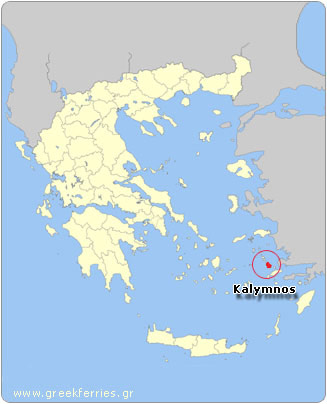
Kalymnos is one of the regional units of Greece. It is part of the region of South Aegean. The regional unit covers the islands of Kalymnos, Agathonisi, Astypalaia, Leipsoi, Leros, Patmos and several smaller islands in the Aegean Sea.
Kalymnos
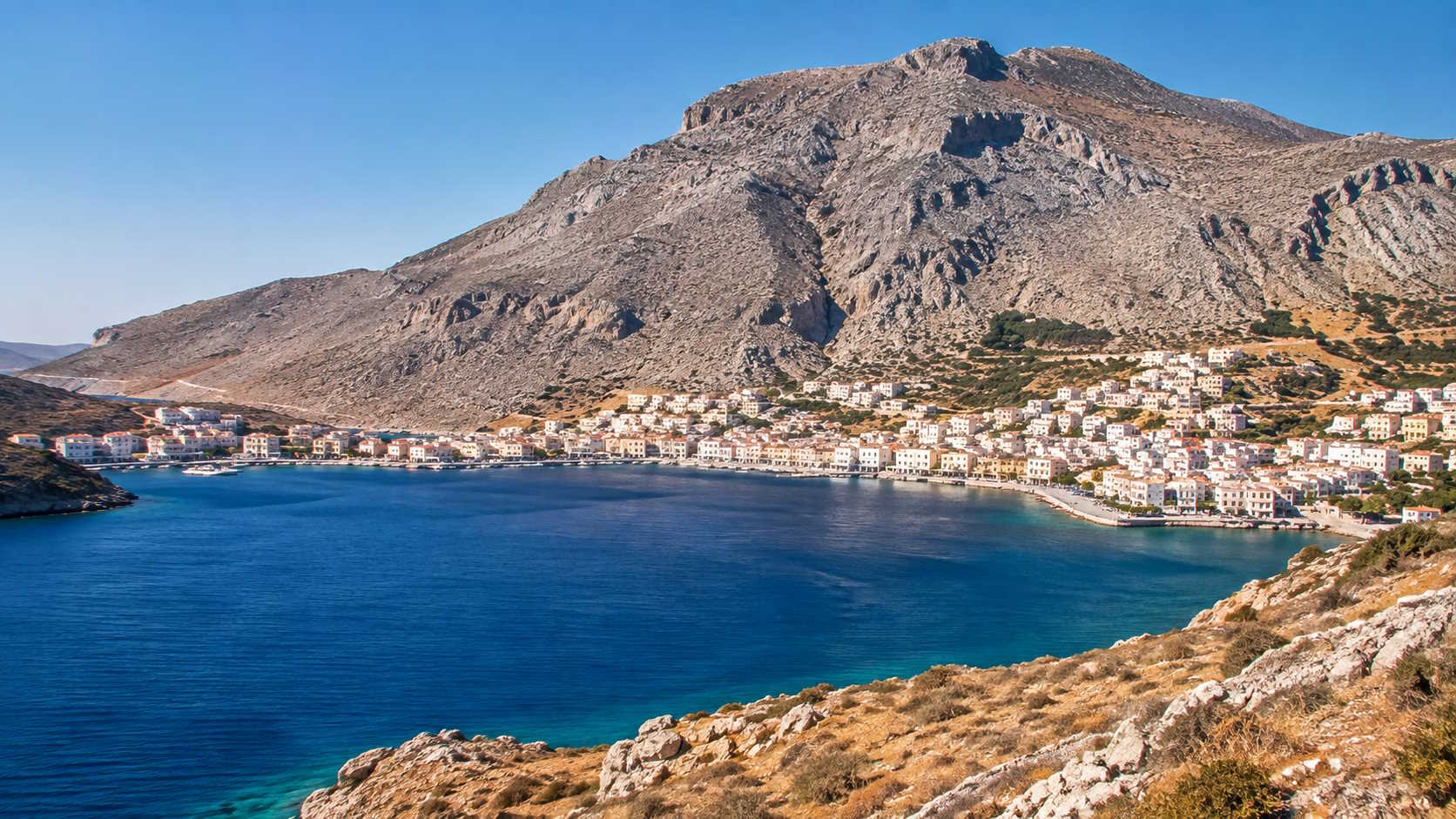
Kalymnos between the islands of Kos and Leros lies the fourth largest island of the Dodecanese Group: Kalymnos. The capital of the island is the picturesque Pothia, where about 11,000 people live. The port of Kalymnos is located in Pothia.
Kalymnos is a barren mountainous island with some fertile valleys full of citrus groves. For centuries on the island of Kalymnos, sponge diving was the most common profession. Sponge diving brought wealth and prosperity to the inhabitants of the island. It was sponge divers from Kalymnos who brought air compression techniques to the United States and turned the small sponge diving industry in Tarpon Springs, Florida into flourishing industry in the early 1900s. Tarpon Springs is still well known for its sponge diving industry and its Greektown.
The houses on Kalymnos usually have two or three floors and the roofs are covered with ceramic tiles. There are many churches on the island with beautiful icons. It is worth visiting the Church of Christ the Savior in Kalymnos town as well as the Archaeological Museum, the Cave of the Seven Virgins and the Cave of Kefalas, where archaeological finds are located.
The spectacular beaches are on the west coast of Kalymnos. The most famous are Masouri and Myrties.
Nowadays tourism is the main source of income for the inhabitants of Kalymnos. Kalymnos is an island where alternative tourism is possible like diving, windsurfing, fishing and hiking. Kalymnos also offers great climbing opportunities in a scenic setting. The rock formations are of climbing quality (limestone) and the area offers plenty of variety for climbing excursions. There are many starting points to begin a climb. The best times to climb in Kalymnos are the cooler spring and autumn. The summer temperatures are very high.
Kalymnos is a charming island that has kept its own identity. The population is welcoming and friendly and the island has good facilities for tourists.
Sights and tips Kalymnos
- The village of Emborios is located about 23 kilometers (14 mi) from the capital Pothia. It is the northernmost village on the island. There is a small harbor and a pretty beach. Restaurants and a small supermarket line the small promenade.
- The village Masouri: Masouri is located on the west coast of Kalymnos, 10 kilometers (6 mi) from Pothia. It is one of the most popular resorts on the island and is home to one of the best beaches.
- The village of Myrties is also located on the west coast of Kalymnos. It lies next to Masouri. It got is name from the myrtle trees that grow here. There is a pebbly beach here.
- The Byzantine fortress near the village of Masouri.
- The fortress Monastery of Panagia Kyra Psili. This fortress is dedicated to Virgin Mary and is located on a steel rock, near the village of Metochi (5 kilometers/3 miles from Pothia).
- The fortress of Chorio: This fortress was first built by the Byzantines, then later rebuilt by the Knights of Rhodes. The ruins of the fortress and 9 churches are scattered on the top of a hill.
- The quiet hamlet of Emborios that lies to the north.
- At Therma, one kilometer from Pothia, you’ll find the therapeutic bathing springs of Kalymnos.
Leros
Leros, located between Patmos and Kalymnos, is an island with fertile valleys, green hills and spectacular beaches. There are olive groves, some of which are dramatically located on terraces on the mountain slopes.
The capital of Leros is Agia Marina, which is adjacent to the villages of Platanos and Panteli situated on the other side of the hill. Laki, which is located three kilometers (less than 2 miles) south of Agia Marina, is the main port of the island. This is one of the largest and best natural harbors in the Mediterranean. Alinda, Xerokambos and Partheni are pleasant coastal towns. You can swim at the beaches of Agia Marina, Panteli, Vromolithos, Alinda, Laki, Merikia and Xerokambos.
Leros is one of the smaller islands of the Dodecanese. It covers an area of 53 km2 (20 mi2), has a 71 km (44 mi) coastline and a population of 8,100. It is an island with many bays, beautiful natural harbors, sandy beaches and a good tourist infrastructure. There are archaeological sites, castles, mansions and Italian colonial architecture buildings.
Leros has been inhabited since the Neolithic period with a history similar to the other islands of the Dodecanese. During the Italian occupation Leros was of strategic importance. Scattered in the mountains lie the remains of two Byzantine fortresses. From the island, there is a magnificent view of the coastline indented with deep bays.
Sights and tips island Leros
- Platanos, Agia Marina and Panteli are three connected settlements that together form the capital. Of these three places Platanos is the oldest.
- The mansions Kandioglou and Antonellou.
- The beautiful churches.
- The well-preserved castle with traces of the ancient Greek era. It obtained its present form at the time of the Venetians. The Panagia Kera monastery is situated within the castle. Built in 1300 AD, it is decorated with beautiful icons and an old Greek Byzantine collection.
- Fortress Broutzi - a Roman fortress in the harbor.
- Remains of an early Christian basilica with mosaics, in Agia Marina.
- The archaeological museum with artifacts from prehistoric times to the early Christian period.
- The whitewashed port town of Laki is located on a scenic, sheltered cove.
- Hidden in the bays there are a few small and quiet sandy beaches, especially in Xerokambos, Agia Marina, Aghios Stefanos, Panteli and Gournoi.
- Activities on Leros: swimming, biking, hiking and diving.
- The marina of Laki.
Patmos
Patmos is the northernmost island of the archipelago Dodecanese. The name Dodecanese means "twelve islands.”
Patmos, situated between Leros and Ikaria, is a hilly volcanic island with its highest peak being Profitis Ilias at 270 meters (885 ft). The island boasts many bays and the middle portion of the island is very narrow. The width here is less than 2 kilometers (a little over a mile).
There are approximately 3,000 people living here. The inhabitants of Patmos engage in agriculture, pottery and fishing.
Patmos is known as the Jerusalem of the Aegean Sea, for here the apostle John spent eighteen months in a cave at 95 AD, according to tradition he was inspired to write the Book of Revelation, the last book of the New Testament.
Later, in 1088 during the reign of Byzantine Emperor Alexios the 1st, a monastery was founded by the monk Christodoulos in honor of the apostle. Visitors are allowed to walk around the courtyard and through the hallways. The monastery has a wealth of Byzantine artifacts, including icons, carvings of gold, silver and gemstones. On the second floor there is a library with lots of manuscripts, old books and charters. The Monastery is situated 3 kilometers (less than 2 mi) from Skala, the port of the island. Skala has a friendly atmosphere, and charming taverns, hotels and shops.
Lipsi (Leipsoi)
Lipsi (Leipsoi), is a Greek island located east of Patmos and north of Leros and belongs to the Dodecanese island group. The history of the island is similar to the other islands of the Dodecanese.
The only town on the island is also called Lipsi. The picturesque village with whitewashed houses lies on a hillside at the end of a deep inlet. They say Lipsi was founded by Cretans (natives of the Greek island of Crete). In the harbor, you will immediately notice the church of Aghios Ioannis with its blue dome. The Nikiforion Museum is also worth a visit. There are some nice beaches on the island such as Platis Gialos. The island is surrounded by a number of uninhabited rocky islands. Most of Lipsi’s inhabitants are fishermen. Once wine was produced here, that was of very high quality and even today, residents use the hilly landscape (highest point 271 m/almost 1000 feet) mainly for the cultivation of grapes and melons.
Lipsi is a small island. It covers an area of 16 square kilometers (6 mi2). The length of the coastline is 35 kilometers (22 mi) and its population is 610 people. It is an island with low hills, bushes, wooded shores and small valleys. It is ideal for quiet vacations.
Sights and tips Lipsi
Lipsi, the only settlement on the island, was founded around 1670. The church of Aghios Ioannis dominates. All the beaches are clean enough for swimming. The beaches of Lientou, Kampos, Elena, Katsadia, Papandria, Chochlakoura, Mykonos Town and Monodendri are all close to town.
Other sights on Lipsi are:
- The castle with remains of buildings and tombs.
- Several old churches with beautiful icons like the church of Aghios Ioannis Theologos and Panagia tou Charou.
- The folk museum with icons, liturgical and traditional objects.
Events that are celebrated here are:
- Easter
- On June 24 the Feast of Klidonas.
- On August 23 the celebration of the Virgin Mary.
- From August 15 to 30, a wine festival with delicious wine and folk dancing.
Astypalaia (Astypalea)
Astypalaia (Astypalea) is a small mountainous island whose name literally means "old town.” When you look at the map, Astypalaia looks like it consists of two smaller islands, connected to each other with a narrow strip of land.
Although Astypalaia is a Dodecanese island, it’s actually located between the Dodecanese and Cyclades, it could so easily have been a Cycladic island. The capital of Astypalaia is Chora, a small town built amphitheatrically on a hill. At the top of the hill you see the castle (Guerini castle) from the Venetian era.
As you approach the port of Astypalaia you’ll have a beautiful view of the typical white houses on the slopes of the hill and beyond to the castle. The port is called Pera Gialo, and is located at the bottom of the hill of Chora.
The attractive traditional whitewashed buildings, the landscapes and the architecture are quite similar to those in the Cyclades. One of the most beautiful churches is the church of Panagia Portaitissa, which is just below the castle. Take a pleasant walk through the streets and alleys of Chora.
The Greek cafes are quaint and the atmosphere is lovely. At the harbor itself there are nice restaurants and pretty terraces. Most accommodations on the island are located near the port.
Just like all other Greek islands, on Astypalaia there are many beautiful beaches. The beach Livadi is the most well known and is situated near Chora. One can take a boat to visit other beaches.
Visit the narrow strip in the middle of the "islets," where it is very green and the water is very shallow. At Vathi you can visit the Cave of the Dragon where very striking stalactites and stalagmites have grown.
Area attractions Astypalaia
- The Venetian Castle of the Guerini dynasty
- The Church of Panagia Portaitissa 1672 AD
- The Archaeological museum
- The Ecclesiastical museum
- Analipsi, a village 9 km (almost 6 mi) from Chora
- The Roman baths of Talara
- The church and the Cave of Panagia Poulariani
- Vathi, a village 20 kilometers (12 mi) northwest of the port, with its Minoan remains and dragon's cave (Drakos)
- The beaches of Livadi, Vatses, Panormo, Pachia Ammos
- The Cave of Negros, reachable by boat via Livadi
Feasts on Astypalaia
- The feast of Panagia (Holy Mother) Flevariotissa on February 2
- The feast of Panagia Poulariani on September 8
Agathonissi
Agathonissi is a small island that lies near Kalymnos and the Turkish coast. Agathonissi literally means "Island of the good / brave / innocent / naïve," and accurately describes the characteristics of the people who live here. Agathonissi is not a busy tourist island but it is worth a visit. You will enjoy the many cafes and beautiful beaches. Although there are many hotels and apartments, in the peak summer season it is sometimes difficult to find accommodations.
Most of the inhabitants of the island are professional fishermen. The fish is sold on the local market or at the fish market on the island of Samos.
Agathonissi is accessible, daily, by boat from Patmos. Agathonisi was first called Tragea or Tragia. In ancient times the island was inhabited by the Ionians of Militos. This is illustrated by the ancient ruins on Agathonissi, dating from those times. Its present name was given by a teacher/priest Gianni Panagiotou, who came from the island of Fourni and worked in Agathonissi during the second and third decades of the last century.
The current name reflects the good nature of its inhabitants. Agatho means “good.” The island has had several occupiers in previous centuries, (Turks, Italians, Germans) before it became part of Greece. There are about 110 residents on the island today, the majority of them lives in Megalo Chorio (Big Village), the oldest village of the island. Beautiful houses with a special architectural style, punctuate the village.
Sights and what to do on Agathonissi?
- Tholi has Byzantine ruins of the 11th century.
- In the northern part of the island there are ancient ruins in the area of Kastraki.
- There are also ancient settlements in the area of Aghios Ioannis and Alonia.
- The peaceful life on the island, the tranquility, the hospitality of the people and the beauty of the beaches of Agathonisi make it an ideal place for those who prefer a quiet holiday, far from crowded tourism.
- There are plenty of rooms and apartments in Agathonisi but not in high season. If you come in July or August, you better book in advance.
Περιφερειακή Ενότητα Καλύμνου
πληθυσμός 2021: 31.383
-
Δήμος Αγαθονησίου
-
Δήμος Αστυπάλαιας
-
Δήμος Καλυμνίων
-
Δήμος Λειψών
-
Δήμος Λέρου
-
Δήμος Πάτμου
Add a review